George Washington and the American Revolution, 1775-1776
Click here to enter exhibit
Exit FullScreen
Enter code to exit FullScreen
Dot of
1
2
4
0
1
E40 - Portrait of George Washington
3
0
5
0
2
1774 New England
0
0
4
0
3
E40 - 1775 Boston Harbor
0
0
5
0
4
E40 - 1775 Breeds Hill
0
0
0
0
5
E40 - The Death of General Warren
0
0
0
0
6
E40 - Evacuation Day Boston
0
0
5
0
7
1776 City of New York - Bernard Ratzer
0
0
0
0
8
E40 - General Howe
1
1
7
0
9
1773 - Ratzer Lower Manhattan
0
1
11
0
10
1776 New York Campaign Map
1
0
0
0
11
E40 - 1776 Howe's War Plan
0
0
0
0
12
E40 - 1776 Howe's War Plan - State 5
0
0
0
0
13
E40 - The Beach at Gravesend Bay
0
0
6
0
14
Battle of Brooklyn - General Grants Position
0
0
4
0
15
1776 Battle of Long Island
0
0
0
0
16
E40 - The Old Stone House in Brooklyn
0
0
0
0
17
E40 - A View of Gowanus Creek in Brooklyn
0
0
0
0
18
E40 - A View of Manhattan from Brooklyn
0
0
8
0
19
1878 Johnston Map of Manhattan in 1776
0
0
0
0
20
E40 - A View from Kip's Bay Looking East
0
0
0
0
21
E40 - Plaque at the Site of Murray Mansion
0
0
4
0
22
1777 Fort Washington Map
0
0
4
0
23
1776 View of Attack on Fort Washington
0
0
0
0
24
E40 - Memorial at the Site of Fort Washington
0
0
5
0
25
1776 Holland Map of New York and New Jersey
0
0
6
0
26
1851 Emmanuel Leutze - Washington Crossing the Delaware
0
0
0
0
27
E40 - A View of the Crossing Site from Pennsylvania
0
0
0
0
28
E40 - Re-enactment Showing the Durham Boat
0
0
7
0
29
1777 Trenton Map
0
0
0
0
30
E40 - Surrender at Trenton by John Trumbull
0
0
0
0
31
E40 - Battle of Trenton Memorial
0
0
0
0
32
E40 - Princeton Battlefield State Park
0
0
0
0
33
E40 - William Faden Cartographer by John Russell
0
0
5
0
34
Surrender at Yorktown
0
0
0
0
35
E40 - The Long Shot
0
0
2
0
36
Mt Vernon Map of The New York Campaign
0
0
1
0
37
E40 - 1776 New York Campaign Map CLONED
Image 1 of 37
| Image: 155 | Size: 1439x1798px
E40 - Portrait of George Washington
In the aftermath of the French and Indian War (1754-1763) , American colonists believed they deserved greater political freedoms from the British government, but King George III and his ministers faced a heavy war debt and were intent on levying new taxes on the colonists. Political leaders in North America raised new issues dealing with inequality of powers, individual freedom, separation of church and state, and political rights. Painting by Charles Willson Peale. / Image courtesy of Crystal Bridges Museum of American Art.
Image 3 of 37
| Image: 140 | Size: 8048x5776px
E40 - 1775 Boston Harbor
This charming map was based upon the observations of a British military engineer, Lt. Page, and was printed in 1775, after the battles at Lexington and Concord on April 19. As shown on the map, the British Army held Boston, then a town on a peninsula of 10,000 population, and the powerful Royal Navy controlled the harbor and rivers, but the Continental Army built fortifications (“Rebel Works”) to surround the British. Note hamlet of Charlestown across the river to north of Boston and "Dorchester Hill" to the south. Map author Thomas Hyde, 1775. / Image courtesy of Norman B. Leventhal Map & Education Center.
Image 4 of 37
| Image: 141 | Size: 8040x9010px
E40 - 1775 Breeds Hill
On morning of June 17th, 1775, the British awoke to find that the Americans had fortified a new position across the river, above Charleston. From these positions, American cannon threatened the British in Boston, and the British had to dislodge the Americans. As shown in the 1797 version of map, British ships opened fire on the American positions while British troops were ferried to the beaches below the American positions. Determined American militia beat back two attacks by the British, who suffered heavy casualties. Then, with American ammunition depleted, a third British assault finally routed the Americans. George Washington arrived in Boston to take command in July, and throughout the fall and most of the winter 1775-1776, there was stalemate, but in March 1776, Washington brilliantly took advantage of a British oversight. He fortified Dorchester Heights (see previous map) and forced the British to evacuate on March 17, 1776, sailing off to Halifax, Nova Scotia. Published by C. Smith 1797. / Image courtesy of Norman B. Leventhal Map & Education Center.
Image 7 of 37
| Image: 142 | Size: 12352x16598px
1776 City of New York - Bernard Ratzer
Washington knew that the British would have to return, and he reasoned that the most likely target would be New York City. As shown in this iconic map by British Lt. Bernard Ratzer, surveyed in 1767 and printed in 1776, the geography of New York was favorable for His Majesty’s Forces. At the bottom of the map, there is a magnificent view of what it was like to sail into the harbor in the late 18th Century. New York City was on Manhattan Island, and the network of the Hudson and East Rivers and New York Bay was easily controlled by the Royal Navy. The British could decide where and when to attack! Control of New York would separate the rebellious New England colonies from the Middle and Southern colonies. Further, New York with its population of 20,000 was second in size only to Philadelphia among cities in North America, and New York had many Loyalists.
Beginning in spring 1776, Washington began to move his army from Boston to New York and await the enemy. In late July, American hearts sank as they witnessed the British fleet sail into New York Bay. It had over 100 ships—the largest fleet ever sent to American waters—and carrying 30,000 British troops and German mercenaries. Washington’s army peaked at less than 20,000, but most were raw, unproved militia. Map surveyed by Bernard Ratzer in 1766 and 1767. Map engraved by Thomas Kitchin and published by Jefferys and Faden in 1776. / Image courtesy of The Miriam and Ira D. Wallach Division of Art, Prints and Photographs: Print Collection, The New York Public Library.
Image 8 of 37
| Image: 162 | Size: 1280x720px
E40 - General Howe
Now the British Army is under command of General William Howe, who led the attack on Bunker Hill. The Royal Navy is under command of his brother, Admiral Richard Howe, called Black Dick by his men, owing to his swarthy complexion.
The Brothers Howe disembark the army at Staten Island to refit after the long voyage from NOVA SCOTIA . It is late July, 1776. Just a few weeks ago- on July 4- the members of the Continental Congress signed the Declaration of Independence from England- but now the cause of independences faces a grave threat.
GENERAL HOWE is a VETERAN COMMANDER, SUPERB TACTITIAN, AND WISE TO WAR IN NORTH AMERICA. BUT, HE LIKES AMERICANS, IS TRYING TO END THE REBELLION WITH MINIMAL BLOODSHED, AND ULTIMATELY LETS OPPORTUNITIES SLIP THROUGH HIS FINGERS.
Also surveyed in 1767 by Lt. Ratzer, this map shows New York City in detail. It was a city of commerce, and for the late 18th Century it was a tolerant, bustling, and diverse city. It had already been said that New Yorkers spoke “very fast, very loud and all at once.” The North or Hudson River is shown to the left of the city and the East or South River to the right. Some streets including Wall Street and Broadway have kept their names through today. The rest of Manhattan Island remained largely wooded with farms and mansions spaced throughout. Across the East River, there is “Part of Long or Nassau Island,” today this is Brooklyn. Map surveyed by Bernard Ratzer. Published by Kitchin / Jefferys and Faden in 1776. / Image courtesy of Library of Congress, Geography and Map Division.
Image 10 of 37
| Image: 154 | Size: 4298x5143px
1776 New York Campaign Map
This handsome map, by William Faden, Geographer to the King, shows rich topographical and tactical detail , covering the actions of August -September 1776. Note, for example, the British ships landing the troops on Long Island at Gravesend Bay (lower center) and also the landings at Kepp’s (Kip’s) Bay, located at mid-Manhattan (present day 34th Street) at the East River. / Library of Congress, Geography and Map Division.
Image 15 of 37
| Image: 145 | Size: 800x622px
1776 Battle of Long Island
In this 1858 painting by Alonzo Chappel, we witness the scene of The Battle of Brooklyn. The defenders on the American right wing made their stand with a stone house as their center. The Old Stone House still stands today in Brooklyn next to a playground.
Image 19 of 37
| Image: 147 | Size: 6000x2456px
1878 Johnston Map of Manhattan in 1776
Compiled and drawn by Henry P. Johnston in 1878, this map shows, as of 1776, the full 14-mile length of Manhattan in rich topographic detail. South is to the left. Note the grid of New York City at the island’s southern tip, the British landing at Kip’s Bay, and the American fortifications in Harlem Heights. Fort Washington is in upper Manhattan and Fort Constitution, or Fort Lee, is directly across the Hudson River in New Jersey. / Image courtesy of Wikipedia and Geographicus.
Image 20 of 37
| Image: 167 | Size: 1729x950px
E40 - A View from Kip's Bay Looking East
This photo, taken at the foot of 34th Street at the East River shows where the raw American militiamen were entrenched, looking into the East River at the Royal Navy ships. East RIVER IN MIDGROUND. BROOKLYN IN FAR GROUND.
Image 22 of 37
| Image: 152 | Size: 2795x4751px
1777 Fort Washington Map
In 1777, William Faden published this topographical map depicting the capture of Fort Washington in upper Manhattan by combined British-Hessian forces on November 16, 1776. Washington had left the fort with its 2500 men and extensive cache of arms to defend itself, thinking the fort could hold out for weeks. The main American army meanwhile had crossed the Hudson and safely made it to New Jersey. Three columns of British-Hessian forces took the fort in just 5 hours. One column attacked from the south of the fort, a second attacked from the north, and a third made an amphibious landing at Harlem Creek. The loss of Fort Washington was the worst disaster of the war for Washington! / Image courtesy of Library of Congress, Geography and Map Division.
Image 23 of 37
| Image: 148 | Size: 9690x6743px
1776 View of Attack on Fort Washington
Captain Thomas Davies of the Royal Artillery drew this sketch which gives us a true feel of the British amphibious landing from flatboats and the attack on Fort Washington from the Harlem Creek. View is looking south down Harlem Creek (River) from the east bank, in what is now the Bronx. / Image courtesy of The Miriam and Ira D. Wallach Division of Art, Prints and Photographs: Print Collection, The New York Public Library.
Image 25 of 37
| Image: 149 | Size: 6425x16361px
1776 Holland Map of New York and New Jersey
This large map was drawn by the British Major Samuel Holland , Surveyor General, Northern District in America, and was printed by Robert Sayer and John Bennett in 1776. In late November and early December of 1776 the American Army was on the brink of disaster. They had lost every major battle and their forces were dwindling. Washington had no choice but to retreat from his position in Northern New Jersey and seek safety in Pennsylvania, but the British pursued him closely across New Jersey. Washington’s Army eluded the enemy and crossed into Pennsylvania at Trenton in early December 1776. Trenton is located on the map just north of the elbow of the Delaware River. To prevent the British from crossing the Delaware, American engineers destroyed bridges across the river and gathered all boats up and down the river. At least temporarily, Washington’s Army was safe and secure. The British and Hessians, thinking their American foe was beaten, went into winter quarters in a string of posts from the Delaware River back to New York. / Image courtesy of Library of Congress, Geography and Map Division.
Image 26 of 37
| Image: 151 | Size: 6004x3847px
1851 Emmanuel Leutze - Washington Crossing the Delaware
One of the most beloved and well-known artworks in American history, Emmanuel Leutze’s depiction of the heroic crossing was not painted until 75 years later. It contains many historical errors. Notably, the boats do not represent the actual Durham boats used in the crossing, and the flag was not developed until months later. Yet, the painting conjures up the decisiveness of Washington and the patriotism and courage of his men. Painting by Emmanuel Leutze in 1851. / Image courtesy of Smithsonian.
Image 28 of 37
| Image: 171 | Size: 1077x701px
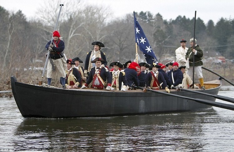
E40 - Re-enactment Showing the Durham Boat
AND if you wanted to know what the boats were really like, well, HERE ARE REPLICAS—THE DURHAM BOATS USED FOR TRAFFIC ON THE DELAWARE IN 18TH CENTURY. MUCH BIGGER THAN ROWBOATS,. Other craft were flat bottomed ferries that were probably used for CANNON & HORSES.
This detailed battle map, published by Willam Faden in 1777, shows the heroic actions of the American forces from December 26, 1776 to January 3, 1777. After crossing the Delaware River into Pennsylvania, the Americans encamped near Newtown (center, left of map). With the integrity of his army at stake, Washington decided on the one course that would save the revolution; he would attack! He chose an isolated Hessian outpost in Trenton, at the very end of the British-Hessian line. On Christmas night 1776, the American Army crossed the Delaware River back into New Jersey at McKonkey’s Ferry (just northeast of Newtown on map). Then the army marched in two divisions, the left down the Pennington Road and the right down the River Road, to attack the Hessians. Catching the enemy by surprise, the result was an hour long battle leading to a small, but complete victory. The Hessian commander was killed, and over 1000 Hessians were taken prisoner. Washington then returned his army to its Pennsylvania encampment, but followed up with another victory a week later in Princeton, New Jersey (northeast of Trenton). The twin victories breathed new life into the cause of independence and led to recognition of Washington as a battlefield commander. The British knew they would now be in for a long struggle if they were to put down the American rebellion. / Image courtesy of Library of Congress, Geography and Map Division.
Image 33 of 37
| Image: 175 | Size: 455x667px
E40 - William Faden Cartographer by John Russell
TAKE a break to say a few words about William Faden (1749-1836), who was one of the most prominent London map makers and dealers of his time. By 1773, he had earned his position as a partner in the map firm of Jeffreys & Faden. In 1776, as the American War of Independence was taking shape, Faden became the sole owner of the business. His timing was perfect as the war created great demand in London for maps of North America, especially battle maps, and Faden’s reputation as a respected map maker and importer served him well. By the time the war ended in 1783, Faden received a royal appointment as Geographer to King George III .
Image 34 of 37
| Image: 156 | Size: 3000x1978px
Surrender at Yorktown
During the Campaign of 1776, no matter what adversity Washington faced, he responded with bravery, an iron will, and determination. He inspired his troops and rallied them time after time. There was no one else in the American colonies who could have done what Washington did. The war would go on another seven years, climaxing with the joint French-American victory at Yorktown, Virginia in 1781. Washington is depicted in the painting center right on horseback. How, after all, did Washington win? He won because he and his men had a cause. He was fighting the right war—keeping his less-experienced army intact, winning just enough times, and gaining the aid of the French. The British Crown and British people had no stomach for more blood and more treasure. Reflecting over the last nearly 250 years, we remember that the entire future of our country hung by a mere thread in the critical months of late 1776 and very early 1777. If just one of several events had gone even a bit differently, imagine how the course of the United States may well have changed. And, indeed, in those five months, the destiny of our country rested heavily on the shoulders of one man, General George Washington. Painting by John Trumbull. / Image courtesy of Architect of the Capitol and Wikipedia.
Image 36 of 37
| Image: 146 | Size: 5100x6600px
Mt Vernon Map of The New York Campaign
In this modern map, we see the sweep on the British attack in summer-fall 1776, beginning with the landing on Long Island in late August 1776, the rout of the Americans at The Battle of Brooklyn, and the attack on Manhattan at Kip’s Bay on September 15, 1776. These were tactical victories for the British, resulting in the retreat of Washington to Harlem Heights in upper Manhattan. In October, the British carried out an amphibious flanking maneuver into Westchester County, requiring Washington to evacuate Harlem Heights and take up new positions above White Plains. However, the Americans left 2500 men and a huge stash of arms at Ft. Washington, in upper Manhattan. / Image courtesy of the Mount Vernon Ladies Association and mtvernon.org.
Image 37 of 37
| Image: 176 | Size: 4298x5143px
E40 - 1776 New York Campaign Map CLONED
This handsome map, by William Faden, Geographer to the King, shows rich topographical and tactical detail , covering the actions of August -September 1776. Note, for example, the British ships landing the troops on Long Island at Gravesend Bay (lower center) and also the landings at Kepp’s (Kip’s) Bay, located at mid-Manhattan (present day 34th Street) at the East River. / Library of Congress, Geography and Map Division.
In the aftermath of the French and Indian War (1754-1763) , American colonists believed they deserved greater political freedoms from the British government, but King George III and his ministers faced a heavy war debt and were intent on levying new taxes on the colonists. Political leaders in North America raised new issues dealing with inequality of powers, individual freedom, separation of church and state, and political rights. Painting by Charles Willson Peale. / Image courtesy of Crystal Bridges Museum of American Art.
This charming map was based upon the observations of a British military engineer, Lt. Page, and was printed in 1775, after the battles at Lexington and Concord on April 19. As shown on the map, the British Army held Boston, then a town on a peninsula of 10,000 population, and the powerful Royal Navy controlled the harbor and rivers, but the Continental Army built fortifications (“Rebel Works”) to surround the British. Note hamlet of Charlestown across the river to north of Boston and "Dorchester Hill" to the south. Map author Thomas Hyde, 1775. / Image courtesy of Norman B. Leventhal Map & Education Center.
On morning of June 17th, 1775, the British awoke to find that the Americans had fortified a new position across the river, above Charleston. From these positions, American cannon threatened the British in Boston, and the British had to dislodge the Americans. As shown in the 1797 version of map, British ships opened fire on the American positions while British troops were ferried to the beaches below the American positions. Determined American militia beat back two attacks by the British, who suffered heavy casualties. Then, with American ammunition depleted, a third British assault finally routed the Americans. George Washington arrived in Boston to take command in July, and throughout the fall and most of the winter 1775-1776, there was stalemate, but in March 1776, Washington brilliantly took advantage of a British oversight. He fortified Dorchester Heights (see previous map) and forced the British to evacuate on March 17, 1776, sailing off to Halifax, Nova Scotia. Published by C. Smith 1797. / Image courtesy of Norman B. Leventhal Map & Education Center.
Washington knew that the British would have to return, and he reasoned that the most likely target would be New York City. As shown in this iconic map by British Lt. Bernard Ratzer, surveyed in 1767 and printed in 1776, the geography of New York was favorable for His Majesty’s Forces. At the bottom of the map, there is a magnificent view of what it was like to sail into the harbor in the late 18th Century. New York City was on Manhattan Island, and the network of the Hudson and East Rivers and New York Bay was easily controlled by the Royal Navy. The British could decide where and when to attack! Control of New York would separate the rebellious New England colonies from the Middle and Southern colonies. Further, New York with its population of 20,000 was second in size only to Philadelphia among cities in North America, and New York had many Loyalists.
Beginning in spring 1776, Washington began to move his army from Boston to New York and await the enemy. In late July, American hearts sank as they witnessed the British fleet sail into New York Bay. It had over 100 ships—the largest fleet ever sent to American waters—and carrying 30,000 British troops and German mercenaries. Washington’s army peaked at less than 20,000, but most were raw, unproved militia. Map surveyed by Bernard Ratzer in 1766 and 1767. Map engraved by Thomas Kitchin and published by Jefferys and Faden in 1776. / Image courtesy of The Miriam and Ira D. Wallach Division of Art, Prints and Photographs: Print Collection, The New York Public Library.
Now the British Army is under command of General William Howe, who led the attack on Bunker Hill. The Royal Navy is under command of his brother, Admiral Richard Howe, called Black Dick by his men, owing to his swarthy complexion.
The Brothers Howe disembark the army at Staten Island to refit after the long voyage from NOVA SCOTIA . It is late July, 1776. Just a few weeks ago- on July 4- the members of the Continental Congress signed the Declaration of Independence from England- but now the cause of independences faces a grave threat.
GENERAL HOWE is a VETERAN COMMANDER, SUPERB TACTITIAN, AND WISE TO WAR IN NORTH AMERICA. BUT, HE LIKES AMERICANS, IS TRYING TO END THE REBELLION WITH MINIMAL BLOODSHED, AND ULTIMATELY LETS OPPORTUNITIES SLIP THROUGH HIS FINGERS.
Also surveyed in 1767 by Lt. Ratzer, this map shows New York City in detail. It was a city of commerce, and for the late 18th Century it was a tolerant, bustling, and diverse city. It had already been said that New Yorkers spoke “very fast, very loud and all at once.” The North or Hudson River is shown to the left of the city and the East or South River to the right. Some streets including Wall Street and Broadway have kept their names through today. The rest of Manhattan Island remained largely wooded with farms and mansions spaced throughout. Across the East River, there is “Part of Long or Nassau Island,” today this is Brooklyn. Map surveyed by Bernard Ratzer. Published by Kitchin / Jefferys and Faden in 1776. / Image courtesy of Library of Congress, Geography and Map Division.
This handsome map, by William Faden, Geographer to the King, shows rich topographical and tactical detail , covering the actions of August -September 1776. Note, for example, the British ships landing the troops on Long Island at Gravesend Bay (lower center) and also the landings at Kepp’s (Kip’s) Bay, located at mid-Manhattan (present day 34th Street) at the East River. / Library of Congress, Geography and Map Division.
In this 1858 painting by Alonzo Chappel, we witness the scene of The Battle of Brooklyn. The defenders on the American right wing made their stand with a stone house as their center. The Old Stone House still stands today in Brooklyn next to a playground.
Compiled and drawn by Henry P. Johnston in 1878, this map shows, as of 1776, the full 14-mile length of Manhattan in rich topographic detail. South is to the left. Note the grid of New York City at the island’s southern tip, the British landing at Kip’s Bay, and the American fortifications in Harlem Heights. Fort Washington is in upper Manhattan and Fort Constitution, or Fort Lee, is directly across the Hudson River in New Jersey. / Image courtesy of Wikipedia and Geographicus.
This photo, taken at the foot of 34th Street at the East River shows where the raw American militiamen were entrenched, looking into the East River at the Royal Navy ships. East RIVER IN MIDGROUND. BROOKLYN IN FAR GROUND.
In 1777, William Faden published this topographical map depicting the capture of Fort Washington in upper Manhattan by combined British-Hessian forces on November 16, 1776. Washington had left the fort with its 2500 men and extensive cache of arms to defend itself, thinking the fort could hold out for weeks. The main American army meanwhile had crossed the Hudson and safely made it to New Jersey. Three columns of British-Hessian forces took the fort in just 5 hours. One column attacked from the south of the fort, a second attacked from the north, and a third made an amphibious landing at Harlem Creek. The loss of Fort Washington was the worst disaster of the war for Washington! / Image courtesy of Library of Congress, Geography and Map Division.
Captain Thomas Davies of the Royal Artillery drew this sketch which gives us a true feel of the British amphibious landing from flatboats and the attack on Fort Washington from the Harlem Creek. View is looking south down Harlem Creek (River) from the east bank, in what is now the Bronx. / Image courtesy of The Miriam and Ira D. Wallach Division of Art, Prints and Photographs: Print Collection, The New York Public Library.
This large map was drawn by the British Major Samuel Holland , Surveyor General, Northern District in America, and was printed by Robert Sayer and John Bennett in 1776. In late November and early December of 1776 the American Army was on the brink of disaster. They had lost every major battle and their forces were dwindling. Washington had no choice but to retreat from his position in Northern New Jersey and seek safety in Pennsylvania, but the British pursued him closely across New Jersey. Washington’s Army eluded the enemy and crossed into Pennsylvania at Trenton in early December 1776. Trenton is located on the map just north of the elbow of the Delaware River. To prevent the British from crossing the Delaware, American engineers destroyed bridges across the river and gathered all boats up and down the river. At least temporarily, Washington’s Army was safe and secure. The British and Hessians, thinking their American foe was beaten, went into winter quarters in a string of posts from the Delaware River back to New York. / Image courtesy of Library of Congress, Geography and Map Division.
1851 Emmanuel Leutze - Washington Crossing the Delaware
One of the most beloved and well-known artworks in American history, Emmanuel Leutze’s depiction of the heroic crossing was not painted until 75 years later. It contains many historical errors. Notably, the boats do not represent the actual Durham boats used in the crossing, and the flag was not developed until months later. Yet, the painting conjures up the decisiveness of Washington and the patriotism and courage of his men. Painting by Emmanuel Leutze in 1851. / Image courtesy of Smithsonian.
AND if you wanted to know what the boats were really like, well, HERE ARE REPLICAS—THE DURHAM BOATS USED FOR TRAFFIC ON THE DELAWARE IN 18TH CENTURY. MUCH BIGGER THAN ROWBOATS,. Other craft were flat bottomed ferries that were probably used for CANNON & HORSES.
This detailed battle map, published by Willam Faden in 1777, shows the heroic actions of the American forces from December 26, 1776 to January 3, 1777. After crossing the Delaware River into Pennsylvania, the Americans encamped near Newtown (center, left of map). With the integrity of his army at stake, Washington decided on the one course that would save the revolution; he would attack! He chose an isolated Hessian outpost in Trenton, at the very end of the British-Hessian line. On Christmas night 1776, the American Army crossed the Delaware River back into New Jersey at McKonkey’s Ferry (just northeast of Newtown on map). Then the army marched in two divisions, the left down the Pennington Road and the right down the River Road, to attack the Hessians. Catching the enemy by surprise, the result was an hour long battle leading to a small, but complete victory. The Hessian commander was killed, and over 1000 Hessians were taken prisoner. Washington then returned his army to its Pennsylvania encampment, but followed up with another victory a week later in Princeton, New Jersey (northeast of Trenton). The twin victories breathed new life into the cause of independence and led to recognition of Washington as a battlefield commander. The British knew they would now be in for a long struggle if they were to put down the American rebellion. / Image courtesy of Library of Congress, Geography and Map Division.
TAKE a break to say a few words about William Faden (1749-1836), who was one of the most prominent London map makers and dealers of his time. By 1773, he had earned his position as a partner in the map firm of Jeffreys & Faden. In 1776, as the American War of Independence was taking shape, Faden became the sole owner of the business. His timing was perfect as the war created great demand in London for maps of North America, especially battle maps, and Faden’s reputation as a respected map maker and importer served him well. By the time the war ended in 1783, Faden received a royal appointment as Geographer to King George III .
During the Campaign of 1776, no matter what adversity Washington faced, he responded with bravery, an iron will, and determination. He inspired his troops and rallied them time after time. There was no one else in the American colonies who could have done what Washington did. The war would go on another seven years, climaxing with the joint French-American victory at Yorktown, Virginia in 1781. Washington is depicted in the painting center right on horseback. How, after all, did Washington win? He won because he and his men had a cause. He was fighting the right war—keeping his less-experienced army intact, winning just enough times, and gaining the aid of the French. The British Crown and British people had no stomach for more blood and more treasure. Reflecting over the last nearly 250 years, we remember that the entire future of our country hung by a mere thread in the critical months of late 1776 and very early 1777. If just one of several events had gone even a bit differently, imagine how the course of the United States may well have changed. And, indeed, in those five months, the destiny of our country rested heavily on the shoulders of one man, General George Washington. Painting by John Trumbull. / Image courtesy of Architect of the Capitol and Wikipedia.
In this modern map, we see the sweep on the British attack in summer-fall 1776, beginning with the landing on Long Island in late August 1776, the rout of the Americans at The Battle of Brooklyn, and the attack on Manhattan at Kip’s Bay on September 15, 1776. These were tactical victories for the British, resulting in the retreat of Washington to Harlem Heights in upper Manhattan. In October, the British carried out an amphibious flanking maneuver into Westchester County, requiring Washington to evacuate Harlem Heights and take up new positions above White Plains. However, the Americans left 2500 men and a huge stash of arms at Ft. Washington, in upper Manhattan. / Image courtesy of the Mount Vernon Ladies Association and mtvernon.org.
This handsome map, by William Faden, Geographer to the King, shows rich topographical and tactical detail , covering the actions of August -September 1776. Note, for example, the British ships landing the troops on Long Island at Gravesend Bay (lower center) and also the landings at Kepp’s (Kip’s) Bay, located at mid-Manhattan (present day 34th Street) at the East River. / Library of Congress, Geography and Map Division.
Here in Lexington on April 19, 1775, the shot "heard 'round the world" was fired. To the west is the town of Concord, where, later that day, the British expedition fought the American militia. The British column retreated to Boston and sustained heavy casualties from the harassing Americans. wikipedia / image
In 1775, the town of Boston was on a peninsula connected by a narrow neck to the mainland.
2
tomadmin
(@tomadmin)
Nov 10 2022
0.35
0.2
Here on Charlestown peninsula in June 1775, the American army constructed fortifications from which they could bombard the British in the town of Boston.
3
tomadmin
(@tomadmin)
Nov 10 2022
0.39
0.47
Thinking Dorchester Hill was not surmountable, the British left this position undefended. In March 1776, Washington surprised the British by taking and fortifying Dorchester Hill. From these heights American canon threatened the British in Boston and forced them to evacuate the town by ship on March 17, 1776. Today that is known in Boston as "Evacuation Day." wikipedia
4
tomadmin
(@tomadmin)
Nov 10 2022
0.37
0.21
The British attacked and ultimately drove the Americans from these positions in the bloody Battle of Bunker Hill on June 17, 1775.
Dots count
5
Dot stories
1
tomadmin
(@tomadmin)
Nov 10 2022
0.8
0.73
While the British army in Boston prepared for the attack on Bunker Hill, Royal Navy ships fired upon the American positions.
2
tomadmin
(@tomadmin)
Nov 10 2022
0.84
0.5
The British forces were ferried from Boston to Charlestown peninsula and formed here for the first attack on Bunker Hill.
3
tomadmin
(@tomadmin)
Nov 10 2022
0.59
0.51
At great cost of killed and wounded, the British ultimately captured the American fortification on their third attempt. The Americans retreated across Charlestown Neck.
4
rgibbs
(@rgibbs)
Nov 10 2022
0.18
0.16
Charlestown Neck, the retreat route of the Americans
#140
5
rgibbs
(@rgibbs)
Nov 10 2022
0.51
0.52
The American earthworks, labeled "Warren's Redoubt," after citizen-soldier-physician Joseph Warren, who was killed at the battle.
Dots count
0
No dots yet
Dots count
0
No dots yet
Dots count
5
Dot stories
1
rgibbs
(@rgibbs)
Nov 10 2022
0.38
0.57
In New York City, there was a population of 20,000 in summer 1776. The pin marks the intersection of Wall Street and Broadway.
2
rgibbs
(@rgibbs)
Nov 10 2022
0.5
1.15
View of New York harbor as seen from Governor's Island (see next dot)
3
rgibbs
(@rgibbs)
Nov 10 2022
0.32
0.75
Point on Governor's Island from which view at bottom of map is seen.
4
rgibbs
(@rgibbs)
Nov 10 2022
0.81
0.13
Kipp's Bay (shown as "Keps Bay" on map) is the point where the British invaded Manhattan on Sunday morning, September 15, 1776.
5
rgibbs
(@rgibbs)
Nov 10 2022
0.97
0.2
"Newtown Inlet" (Newtown Creek) where British forces formed prior to amphibious attack at Kip's Bay
Dots count
0
No dots yet
Dots count
7
Dot stories
1
rgibbs
(@rgibbs)
Nov 10 2022
0.16
0.5
Fort George and Gun Batteries
2
rgibbs
(@rgibbs)
Nov 10 2022
0.22
0.4
Trinity Church
3
rgibbs
(@rgibbs)
Nov 10 2022
0.22
0.52
Fish market
4
rgibbs
(@rgibbs)
Nov 10 2022
0.16
0.54
Barracks
5
rgibbs
(@rgibbs)
Nov 10 2022
0.22
0.49
Synagogue
6
rgibbs
(@rgibbs)
Nov 10 2022
0.2
0.52
The Exchange
7
rgibbs
(@rgibbs)
Nov 10 2022
0.1
0.19
Guide ("References") the landmarks in the city
Dots count
11
Dot stories
1
rgibbs
(@rgibbs)
Nov 10 2022
0.27
1.01
Staten Island where the British Forces landed in late July and rested after their long voyages from Europe and Canada. Here they prepared for the attack on the American positions on Long Island.
2
rgibbs
(@rgibbs)
Nov 10 2022
0.51
1.04
Landing of British at Long Island, Gravesend Bay on August 22, 1776. The Americans, confident in the strength of their inland positions , did not contest the landing.
3
rgibbs
(@rgibbs)
Nov 10 2022
0.6
0.9
Frontal attack by Hessian and British forces on American positions on Heights of Guana, Morning August 27. This attack was merely a feint for the main British column was on a wide flanking maneuver to catch the Americans in a deadly trap.
4
rgibbs
(@rgibbs)
Nov 10 2022
0.75
0.83
Route of British flanking movement
5
rgibbs
(@rgibbs)
Nov 10 2022
0.61
0.84
Retreat of Americans from positions on the heights to fortifications along the East River.
6
rgibbs
(@rgibbs)
Nov 10 2022
0.53
0.78
American fortifications along the East River.
7
rgibbs
(@rgibbs)
Nov 10 2022
0.55
0.74
Evacuation point of American forces from Brooklyn to Manhattan under cover of dense fog, August 29.
8
rgibbs
(@rgibbs)
Nov 10 2022
0.62
0.61
Attack of British at Kip's (Kepp's) Bay , Sunday , September 15
9
rgibbs
(@rgibbs)
Nov 10 2022
0.62
0.24
Washington's Headquarters at Morris Mansion in Harlem Heights in Northern Manhattan
10
tomadmin
(@tomadmin)
Nov 10 2022
0.64
0.4
American sunk vessels here to deter the British from sailing this far, landing troops here and splitting the American forces.
11
tomadmin
(@tomadmin)
Nov 10 2022
0.64
0.4
American sunk vessels here to deter the British from sailing this far, landing troops here and splitting the American forces.
Dots count
0
No dots yet
Dots count
0
No dots yet
Dots count
0
No dots yet
Dots count
6
Dot stories
1
rgibbs
(@rgibbs)
Nov 10 2022
0.55
0.62
American positions on Heights of Guana
2
rgibbs
(@rgibbs)
Nov 10 2022
0.31
0.82
Attack of General Grant (Brit.) on August 27, morning.
3
rgibbs
(@rgibbs)
Nov 10 2022
0.64
0.78
Attack of General von Heister (Hessian troops) on the morning of August 27, 1776.
4
rgibbs
(@rgibbs)
Nov 10 2022
0.89
0.66
Flanking movement of main British column, Aug 26-27, 1776.
5
rgibbs
(@rgibbs)
Nov 10 2022
0.55
0.31
American positions along East River.
6
rgibbs
(@rgibbs)
Nov 10 2022
0.49
0.14
Embarcation point for American retreat to Manhattan under cover of fog.
Dots count
4
Dot stories
1
rgibbs
(@rgibbs)
Nov 10 2022
0.94
0.74
Americans retreating across Gowanus Creek
2
rgibbs
(@rgibbs)
Nov 10 2022
0.7
0.43
The Old Stone House in center or the American Line.
3
rgibbs
(@rgibbs)
Nov 10 2022
0.24
0.43
American officer, possibly General Sterling
4
rgibbs
(@rgibbs)
Nov 10 2022
0.37
0.42
The British Line advancing through the dense gunpowder smoke
Dots count
0
No dots yet
Dots count
0
No dots yet
Dots count
0
No dots yet
Dots count
8
Dot stories
1
admin
(@admin)
Nov 10 2022
0.07
0.23
Trinity Church. The first church on this location was built in 1698 and destroyed as a part of much larger fire on September 20th, 1776, which just days after Washington's retreat from New York. The second church was built in 1790 and destroyed by heavy snow during the winter of 1838 to 1839. The third church was built in 1846 and stands there today.
2
admin
(@admin)
Nov 10 2022
0.29
0.28
Kip's Bay, point of British attack on Sunday, September 15, 1776.
3
admin
(@admin)
Nov 10 2022
0.31
0.26
The Cornfield, where General George Washington met the panicked American troops running from Kip's Bay. He was unable to rally his men and his aides de camp led him back to Harlem Heights.
4
admin
(@admin)
Nov 10 2022
0.28
0.25
Murray Mansion, where General Howe and his officers rested after their landing at Kip's Bay. The British troops halted nearby.
5
admin
(@admin)
Nov 10 2022
0.26
0.2
Putnam's Retreat. While the British troops halted near Murray Mansion, General Putnam led his force of 5,000 from New York City, up the West side of Manhattan, to safety in Harlem Heights.
6
admin
(@admin)
Nov 10 2022
0.73
0.18
Morris House, where General Washington had his headquarters in Harlem Heights from mid-September to mid-October, 1776.
7
admin
(@admin)
Nov 10 2022
0.6
0.17
Harlem Heights Battle. On Monday, September 16, 1776, the Americans probed the British lines on the south side of the Hollow Way. This developed into a full-scale battle with each side sending in reinforcements. Although the Americans pulled back to their defensive positions in Harlem Heights at the end of the day, they acquitted themselves well and made up for the rout the day before at Kip's Bay.
8
admin
(@admin)
Nov 10 2022
0.8
0.14
Fort Washington, an extensive earthen redoubt, intended to prevent Royal Navy ships from sailing up the Hudson.
Dots count
0
No dots yet
Dots count
0
No dots yet
Dots count
4
Dot stories
1
rgibbs
(@rgibbs)
Nov 10 2022
0.62
0.59
Amphibious landing by British and attack from Harlem River. The combined British-Hessian attacks led to the ignominious surrender of the fort in 5 hours. It was the greatest defeat the British handed the Americans in the Northern theater of the war.
2
rgibbs
(@rgibbs)
Nov 10 2022
0.14
0.78
Fort Lee (formerly Fort Constitution) on New Jersey side of the Hudson River
3
tomadmin
(@tomadmin)
Nov 10 2022
0.45
0.61
Fort Washington, an earthen structure, located on the heighest point in Manhattan. It was defended by 2500 men, but they were isolated and unsupported.
4
tomadmin
(@tomadmin)
Nov 10 2022
0.48
0.73
The third attacking column, shown as Point D (DOT 2), advanced from the south under Earl Percy
Dots count
4
Dot stories
1
rgibbs
(@rgibbs)
Nov 10 2022
0.52
0.55
Harlem Creek
2
rgibbs
(@rgibbs)
Nov 10 2022
0.26
0.43
British amphibious force landing northeast of Fort Washington.
3
rgibbs
(@rgibbs)
Nov 10 2022
0.85
0.4
View of New Jersey Pallisades and, just below it, a peek at the Hudson River
4
rgibbs
(@rgibbs)
Nov 10 2022
0.48
0.37
In the distance is Fort Washington
Dots count
0
No dots yet
Dots count
5
Dot stories
1
rgibbs
(@rgibbs)
Nov 10 2022
0.61
1.86
Location of Fort Lee, along the Hudson. Americans evacuated this fort when pressed by the British attack in November.
2
rgibbs
(@rgibbs)
Nov 10 2022
0.41
2.07
Washington retreated across New Jersey, desiring to get his army across the Delaware River and to safety in Pennsylvania. He crossed the Delaware here at Trenton, NJ.
3
rgibbs
(@rgibbs)
Nov 10 2022
0.29
2.15
Philadelphia, the American capital, the largest city in North America, with population of 30,000.
4
rgibbs
(@rgibbs)
Nov 10 2022
0.6
1.91
New York City, on southern tip of Manhattan
5
rgibbs
(@rgibbs)
Nov 10 2022
0.73
0.97
Location of Fort Ticonderoga, captured by the Americans in 1775
Dots count
6
Dot stories
1
rgibbs
(@rgibbs)
Nov 10 2022
0.38
0.22
Washington, the central figure, but he would never have stood so precariously in the crossing!
2
rgibbs
(@rgibbs)
Nov 10 2022
0.59
0.54
The crossing was carried out in Durham boats which were used for river traffic and were much larger and more stable than the row boats depicted in Leutze's painting.
3
rgibbs
(@rgibbs)
Nov 10 2022
0.59
0.16
The stars and stripes , depicted in the painting, did not make its first appearance until well into 1777.
4
rgibbs
(@rgibbs)
Nov 10 2022
0.78
0.27
The small boats would never have been able to transport horses and canon, as shown in the painting.
5
rgibbs
(@rgibbs)
Nov 10 2022
0.07
0.28
The shoreline is that of Leutze's native Germany, not that of New Jersey above Trenton.
6
tomadmin
(@tomadmin)
Nov 10 2022
0.56
0.54
Example of a Durham boat.
Dots count
0
No dots yet
Dots count
0
No dots yet
Dots count
7
Dot stories
1
rgibbs
(@rgibbs)
Nov 10 2022
0.49
0.42
Trenton, NJ- Outpost of 1400 Hessians at end of the long line stretching from New York City.
2
rgibbs
(@rgibbs)
Nov 10 2022
0.07
0.4
An American camp in Pennsylvania, centering around Newtown.
3
rgibbs
(@rgibbs)
Nov 10 2022
0.21
0.25
Washington crosses the Delaware River at McConkey's ferry, night of Dec 25-26, 1776.
4
rgibbs
(@rgibbs)
Nov 10 2022
0.46
0.35
One American column under Ten. Washington and Greene approach Trenton along Pennington Road.
5
rgibbs
(@rgibbs)
Nov 10 2022
0.38
0.36
The other American column under General Sullivan approach from the River Road.
6
rgibbs
(@rgibbs)
Nov 10 2022
0.46
0.39
The two American columns converge on the Hessians simultaneously and rout the garrison in a battle lasting less than an hour.
7
rgibbs
(@rgibbs)
Nov 10 2022
0.78
0.21
A week later, Washington gained another victory at Princeton, NJ. These two military successes saved the cause of American Independence. Washington showed battlefield genius. He had, indeed, made mistakes that year, but he learned. No matter how desperate the campaign had been, he responded with an iron will, bravery and determination.No one else could have done what General George Washington did in that fateful campaign of 1776.
Dots count
0
No dots yet
Dots count
0
No dots yet
Dots count
0
No dots yet
Dots count
0
No dots yet
Dots count
5
Dot stories
1
tomadmin
(@tomadmin)
Nov 10 2022
0.7
0.27
George Washington is in the background because the British commander, General Cornwallis, feigned illness and sent his second in command, General O'Hara. Accordingly, Washington sent his second in command, General Benjamin Lincoln.
2
tomadmin
(@tomadmin)
Nov 10 2022
0.41
0.32
General Charles O'Hara, second in command to General Cornwallis, offering surrender to General Lincoln.
3
rgibbs
(@rgibbs)
Nov 10 2022
0.54
0.29
General Benjamin Lincoln receiving the surrender of British General O'Hara
4
rgibbs
(@rgibbs)
Nov 10 2022
0.87
0.26
Depicted in the ranks of American officers are: Col. Alexander Hamilton, who commanded the Light Infantry;General Henry Knox, Chief of Artillery; and General Anthony ("Mad Anthony") Wayne.
5
rgibbs
(@rgibbs)
Nov 10 2022
0.27
0.3
Prominently depicted is General Rochambeau, the French Commander in Chief.
Dots count
0
No dots yet
Dots count
2
Dot stories
1
rgibbs
(@rgibbs)
Nov 10 2022
0.39
0.38
Hell's gate
2
rgibbs
(@rgibbs)
Nov 10 2022
0.33
1.18
Gravesend Bay
Dots count
1
Dot stories
1
tomadmin
(@tomadmin)
Nov 10 2022
0.59
0.25
Approximate location of Fort Washington
E40 - Portrait of George Washington
1774 New England
E40 - 1775 Boston Harbor
E40 - 1775 Breeds Hill
E40 - The Death of General Warren
E40 - Evacuation Day Boston
1776 City of New York - Bernard Ratzer
E40 - General Howe
1773 - Ratzer Lower Manhattan
1776 New York Campaign Map
E40 - 1776 Howe's War Plan
E40 - 1776 Howe's War Plan - State 5
E40 - The Beach at Gravesend Bay
Battle of Brooklyn - General Grants Position
1776 Battle of Long Island
E40 - The Old Stone House in Brooklyn
E40 - A View of Gowanus Creek in Brooklyn
E40 - A View of Manhattan from Brooklyn
1878 Johnston Map of Manhattan in 1776
E40 - A View from Kip's Bay Looking East
E40 - Plaque at the Site of Murray Mansion
1777 Fort Washington Map
1776 View of Attack on Fort Washington
E40 - Memorial at the Site of Fort Washington
1776 Holland Map of New York and New Jersey
1851 Emmanuel Leutze - Washington Crossing the Delaware
E40 - A View of the Crossing Site from Pennsylvania
E40 - Re-enactment Showing the Durham Boat
1777 Trenton Map
E40 - Surrender at Trenton by John Trumbull
E40 - Battle of Trenton Memorial
E40 - Princeton Battlefield State Park
E40 - William Faden Cartographer by John Russell
Surrender at Yorktown
E40 - The Long Shot
Mt Vernon Map of The New York Campaign
E40 - 1776 New York Campaign Map CLONED
1
2
3
4
1
2
3
4
5
1
2
3
4
1
2
3
4
5
1
2
3
4
5
1
2
3
4
5
6
7
1
2
3
4
5
6
7
8
9
10
11
1
2
3
4
5
6
1
2
3
4
1
2
3
4
5
6
7
8
1
2
3
4
1
2
3
4
1
2
3
4
5
1
2
3
4
5
6
1
2
3
4
5
6
7
1
2
3
4
5
1
2
1
Exhibit ID:40
6
4
93
37
0
George Washington and the American Revolution, 1775-1776
George Washington and the American Revolution, 1775-1776
During the first two, precarious years of the American Revolution, the outcome was often in doubt. The Digital Gallery is pleased to present the exhibit, “George Washington and the American Revolution, 1775-1776,” to chronicle these critical times through historic maps, iconic paintings, and explanatory text. Here you can explore the maps and images related to both the defeats and eventual victories of these campaigns.
See Ron Gibbs' historical novel about George Washington and the American Revolution, The Long Shot.
October 2021: “Terrain and Tactics, British War Plan of 1776,” new article by Ronald Gibbs, Courtney Spikes and Thomas Paper. British General William Howe’s “War Plan illustrates the dichotomy of…[his]…tactical brilliance and his characteristic delays that thwarted his ultimate success. In contrast, General Washington was able to maintain the integrity of his army and keep the cause of American independence alive despite his initial defeats” (excerpt from the article). The article was published on-line in Journal of the American Revolution on October 12, 2021. To read the article, click here.
See video of Ron's February 2021 presentation to the Washington Map Society here. See pdf of Ron's October 2020 presentation to San Francisco Map Fair here.


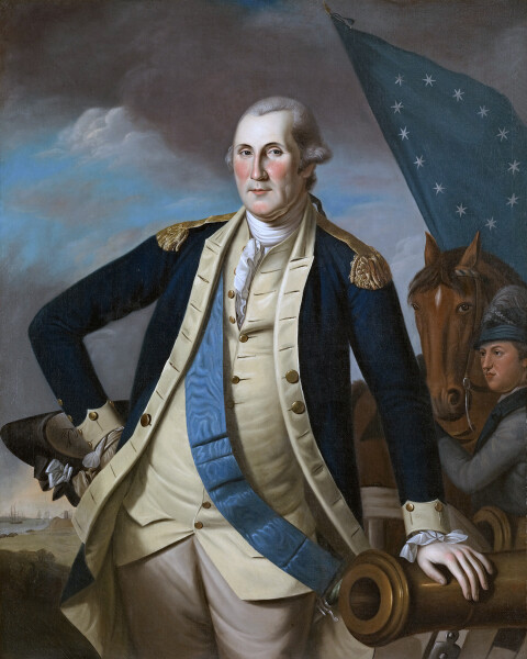
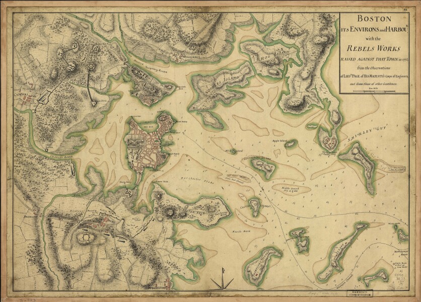
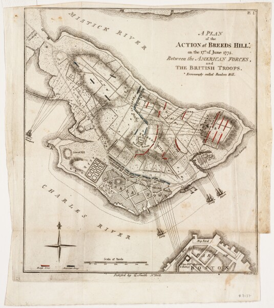
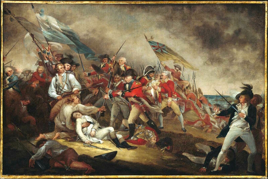
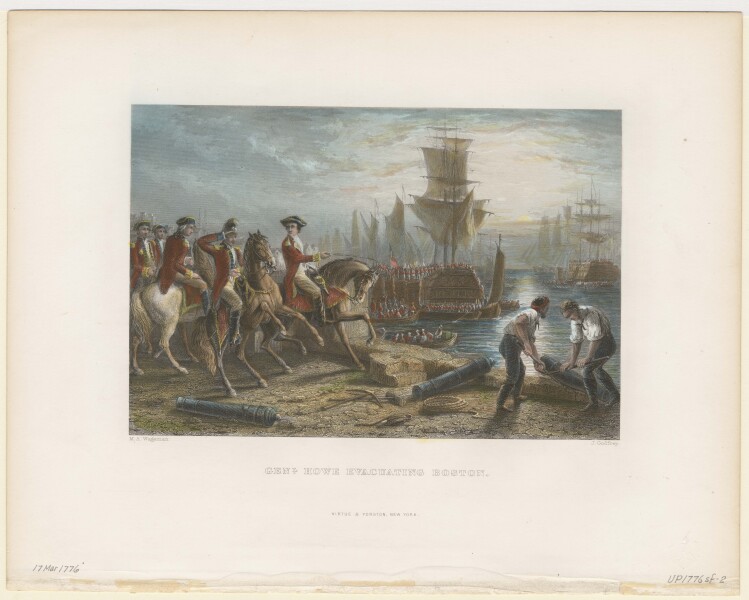
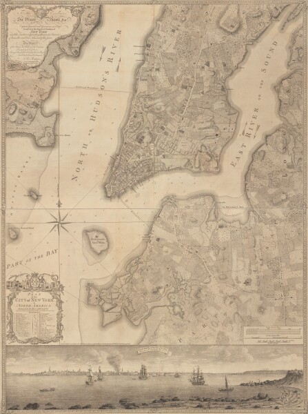
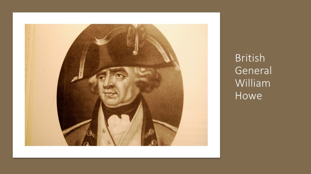
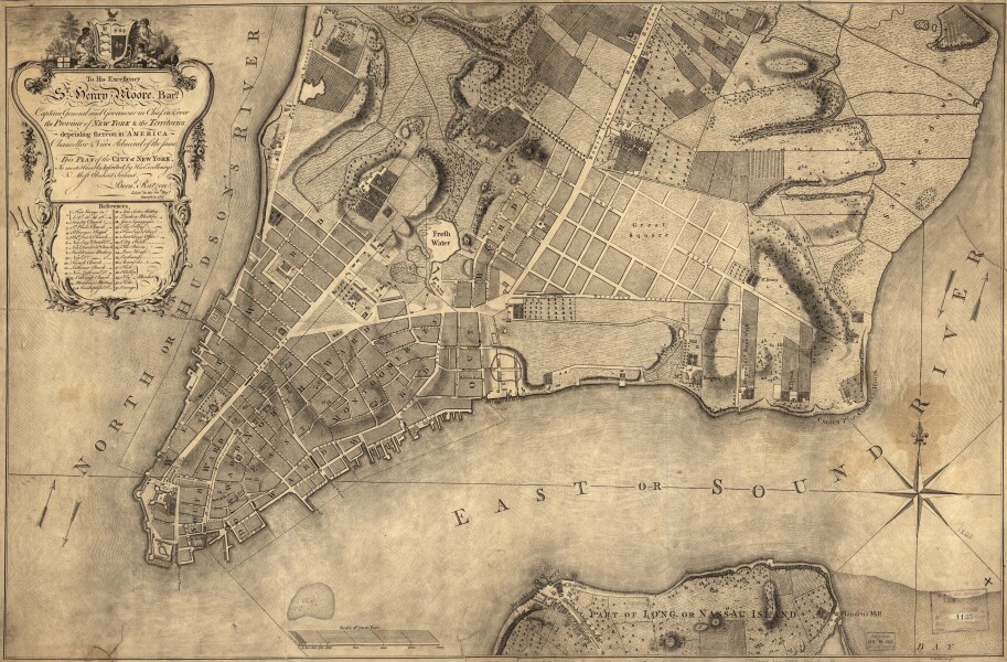

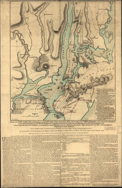
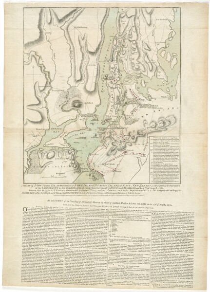
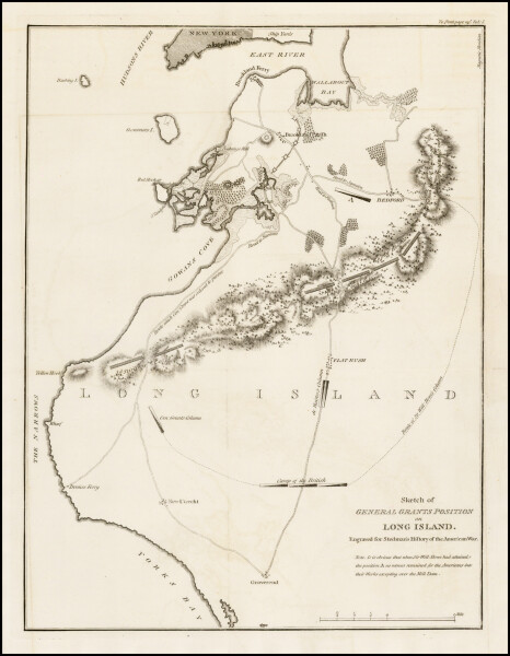
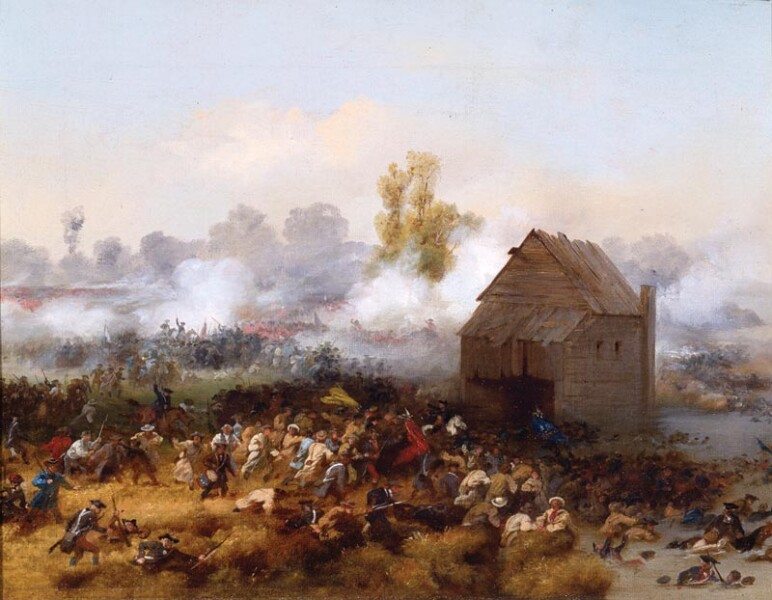
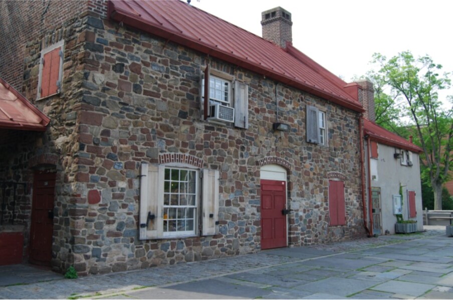
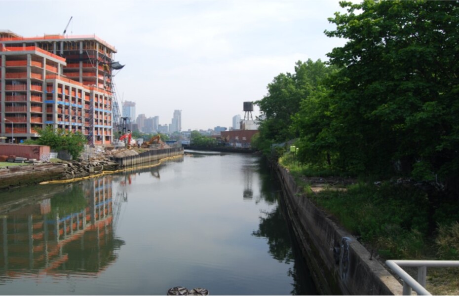
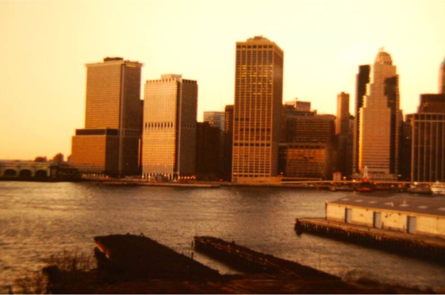
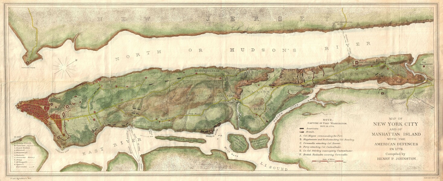
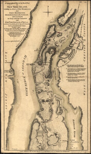
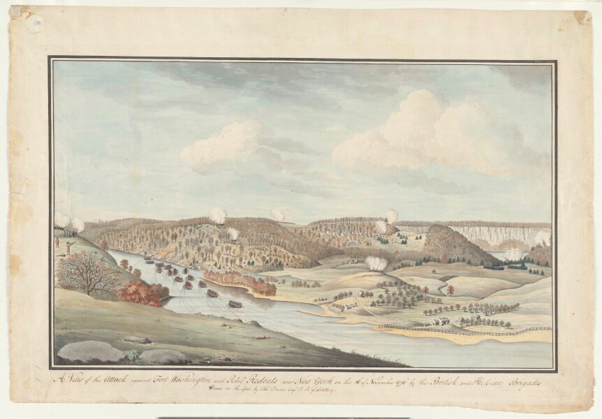
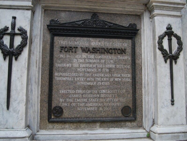
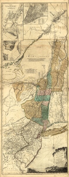
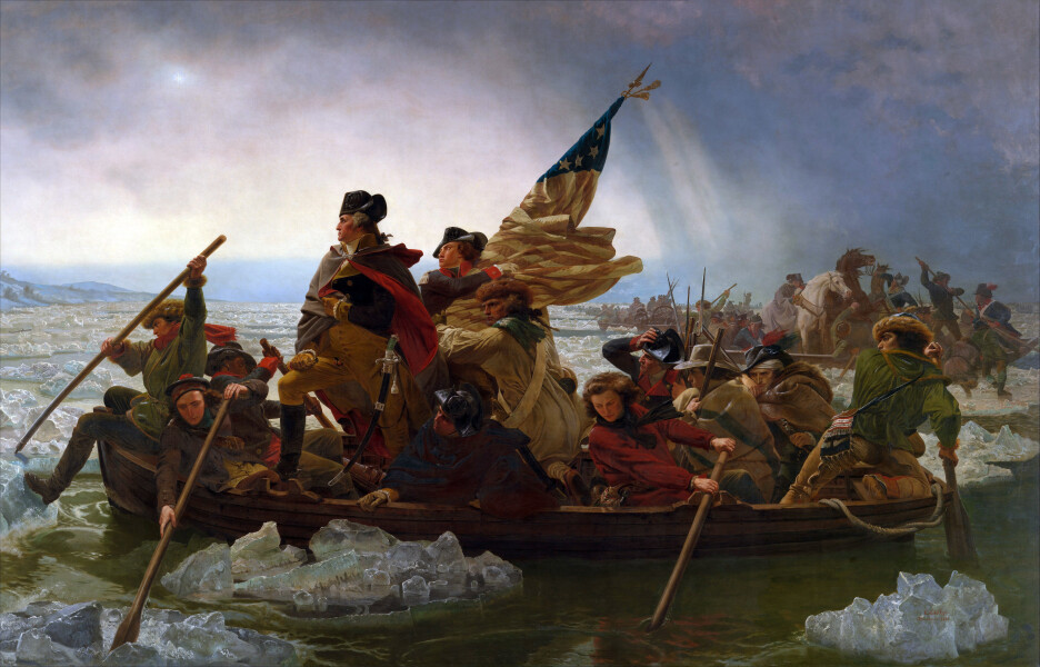

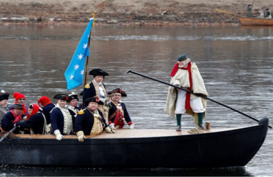
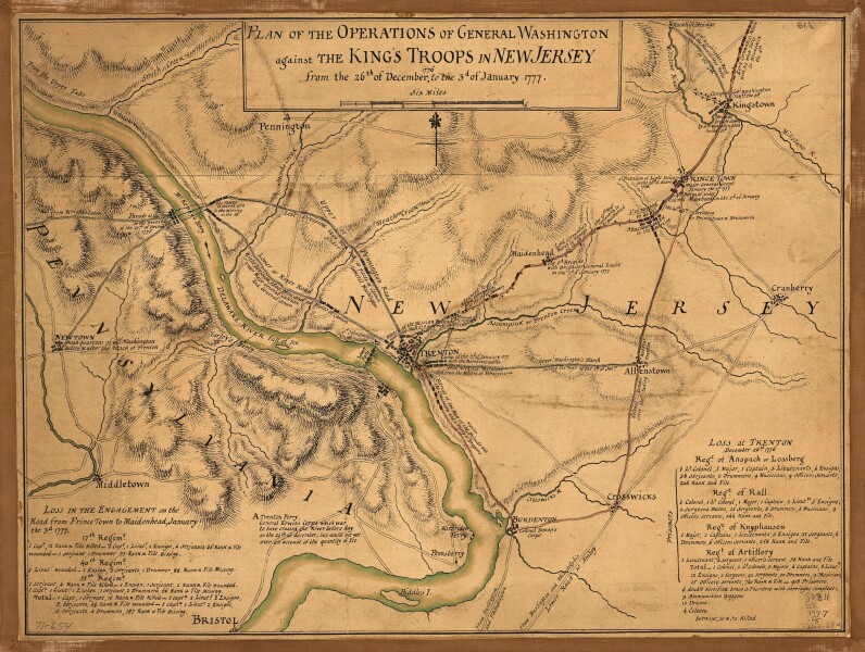
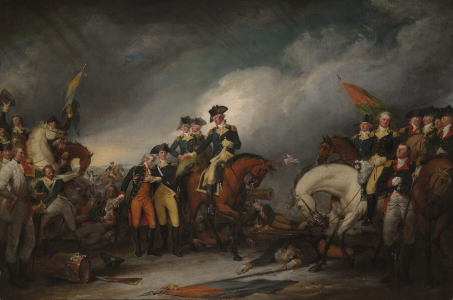
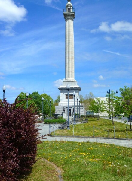
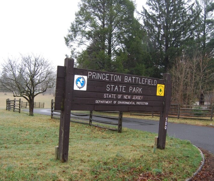

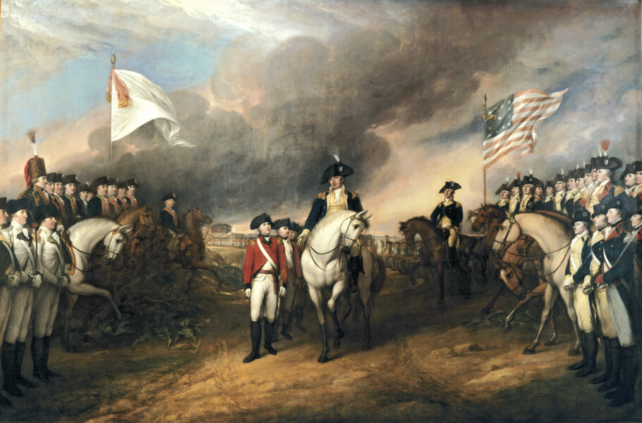

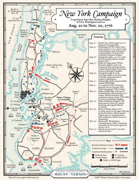
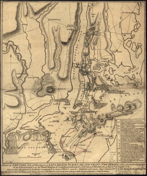
Image here is of Charles Wilson Peale, painter of George Washington at Yorktown. Wikipedia


